Tag Archives: agriculture

BASF Digital Farming builds a STAC-based solution on Amazon EKS

Post Syndicated from Kevin S. Ridolfi original https://aws.amazon.com/blogs/architecture/basf-digital-farming-builds-a-stac-based-solution-on-amazon-eks/

This post was co-written with Frederic Haase and Julian Blau with BASF Digital Farming GmbH.

At xarvio – BASF Digital Farming, our mission is to empower farmers around the world with cutting-edge digital agronomic decision-making tools. Central to this mission is our crop optimization platform, xarvio FIELD MANAGER, which delivers actionable insights through a range of geospatial assets, including satellite imagery, drone data, and application maps from sprayers.

In this post, we show you how we built a scalable geospatial data solution on AWS to efficiently catalog, manage, and visualize both raster and vector datasets through the web. We walk you through our solution based on the SpatioTemporal Asset Catalog (STAC) specification and the open source eoAPI ecosystem, detailing the solution architecture, key technologies, and lessons learned during deployment. This builds upon a previous post on efficient satellite imagery ingestion using AWS Serverless, extending our discussion to the full lifecycle of geospatial data management at scale.

Requirements for our geospatial data solution

BASF Digital Farming’s xarvio FIELD MANAGER platform operates at exceptional scale in the geospatial data ecosystem, processing hundreds of millions of satellite images that translate into STAC items, which further decompose into billions of individual geospatial artifacts. Unlike traditional satellite data providers such as European Space Agency (ESA) who work with predictable, structured data flows, we operate in an inherently dynamic agricultural environment where we ingest near-daily satellite imagery per field from a diverse array of sensors and providers globally. Our mission to support farmers worldwide with advanced digital agronomic decision advice demands a reliable, cloud-based infrastructure capable of handling this massive data velocity and volume and applying advanced quality assurance processes including cloud detection and anomaly detection algorithms. The platform’s true value emerges through our machine learning (ML) pipelines that transform raw satellite data into actionable insights. For example, estimating accurate absolute biomass such as Leaf Area Index (LAI) helps farmers make precise, data-driven agronomic decisions that optimize crop yield and resource utilization across fields worldwide.

STAC and eoAPI ecosystem

To efficiently manage our growing archive of geospatial data, we adopted the Spatio Temporal Asset Catalog (STAC) specification, an open standard that provides a common language to describe and catalog raster and vector datasets. With STAC, we can standardize metadata across diverse sources like satellite imagery, UAV datasets, and prescription maps, making it straightforward to search, filter, and retrieve assets across our platform. We built our platform using the eoAPI ecosystem, an integrated suite of open source tools designed to handle the full lifecycle of geospatial data on the cloud. At its core is pgSTAC, which provides a performant PostGIS-backed STAC API implementation. With pgSTAC, we can index millions of STACi Items efficiently, with support for spatial, temporal, and attribute-based filtering at scale. On top of that, we use Tiles in PostGIS (TiPG) to serve tiled vector data directly from our PostGIS database. This enables real-time visualization of field boundaries, management zones, and application histories as lightweight Mapbox Vector Tiles (MVT), without requiring an external tile server. For raster assets, including satellite and drone imagery, we rely on TiTiler, a modern dynamic tile server built for Cloud Optimized GeoTIFFs (COGs). With TiTiler, we can stream imagery on-demand as WMTS or XYZ tiles, perform dynamic rendering (such as NDVI or false color composites), and integrate seamlessly into web maps and mobile apps.

Solution overview

The following architecture diagram shows how we implemented our geospatial data platform on AWS. In this section, we explain each component of the architecture and how they work together to process millions of satellite images and geospatial assets daily. The solution uses Amazon Elastic Kubernetes Service (Amazon EKS) as the core computing platform, with Amazon Simple Storage Service (Amazon S3) for storage and Amazon Relational Database Service (Amazon RDS) for metadata management. We break down the architecture into four main layers: core services, storage, database, and ingestion.
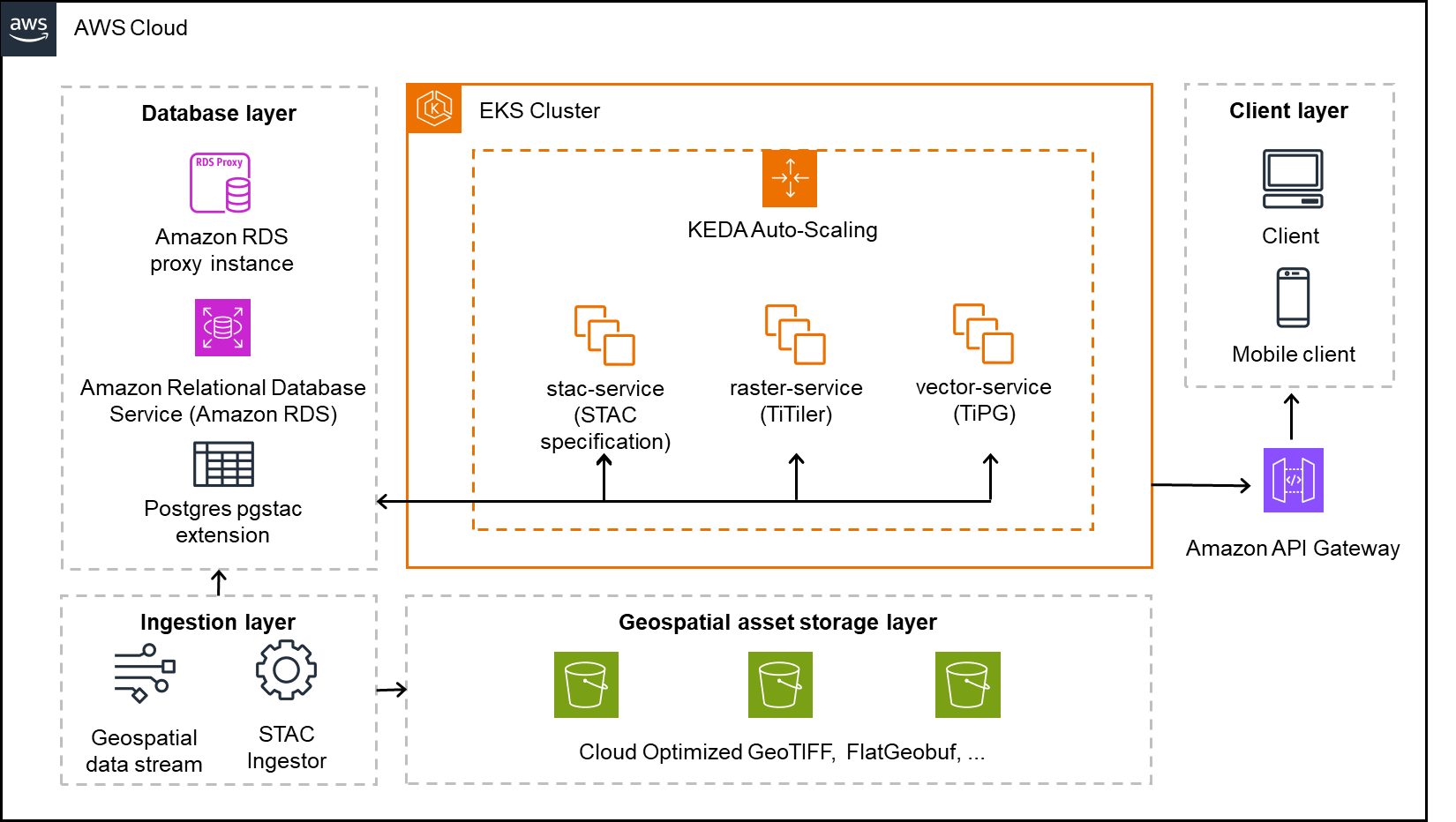
A detailed AWS Cloud architecture visualization showcasing a complete geospatial data processing system across four distinct layers. The database layer features an EKS Cluster managing STAC, raster, and vector services, all connected to Amazon RDS through a proxy instance. The client layer supports both desktop and mobile access via Amazon API Gateway. The ingestion layer processes geospatial data streams through a STAC ingestor, feeding into a robust storage layer utilizing Cloud Optimized GeoTIFF and FlatGeobuf technologies. The architecture emphasizes scalability and efficient spatial data handling through PostgreSQL with pgstac extension, enabling seamless integration of various geospatial services and data formats.

Core services layer

The solution uses an EKS cluster hosting three key services:

  • stac-service – Implements the STAC API specification to catalog and serve metadata for both raster and vector datasets
  • raster-service – Powered by TiTiler, this service dynamically renders and tiles cloud-optimized raster data (for example, COGs) for seamless integration into web and mobile maps
  • vector-service – Built with TiPG, this component serves vector data (for example, boundaries or application zones) as tiled MVT layers directly from the database or from Amazon S3

These services are containerized and orchestrated within Kubernetes, allowing for high availability, modular separation, and simplified continuous integration and delivery (CI/CD) workflows.

KEDA-based automatic scaling

We use Kubernetes Event-Driven Autoscaling (KEDA) to scale our platform services dynamically based on real-time workloads. With KEDA, we can scale individual pods based on precise event-driven metrics such as the STAC ingestion queue depth or visualization request load. This supports responsive performance during peak activity while maintaining lean resource usage during idle periods, aligning perfectly with our need for elasticity in a data-intensive, variable-load environment.

Geospatial asset storage layer

The platform stores all raw and processed geospatial assets in S3 buckets, optimized for performance and durability. This layer holds COGs for raster imagery and FlatGeobuf or similar formats for vector data. These formats are chosen for their support of streaming access, indexing, and cloud-based performance.

Database layer

The metadata backbone of the system is a PostgreSQL database hosted on Amazon RDS, extended with the pgSTAC plugin. This setup enables efficient indexing and querying of millions of STAC items and collections. An RDS proxy sits in front of the database, providing connection pooling and resiliency, especially under bursty or concurrent access patterns common in geospatial applications.

Ingestion layer

An independent ingestion component handles batch or streaming geospatial data inputs. This component processes satellite imagery, drone data, or prescription maps and pushes relevant metadata into the STAC API and storage assets into Amazon S3. The ingestion engine is decoupled from serving infrastructure, enabling asynchronous and large-scale data loading.

Amazon API Gateway and clients

Public access to the platform is handled through Amazon API Gateway, allowing clients—whether browser-based or mobile—to interact securely with the services. The API gateway provides a unified entrypoint and is used for applying rate limiting, authorization, and routing policies.

Solution benefits

The solution offers the following benefits:

  • Rapid onboarding with STAC standardization – By aligning with the STAC specification, we’ve significantly reduced the time to onboard new data domains like sprayer application maps. Compared to previous approaches in our legacy system, metadata modeling and integration are now both standardized and automated, so we can expose new geospatial data products to clients in days instead of weeks or months.
  • Optimized storage with COGs and Amazon S3 – Storing raster and vector assets in Amazon S3 using cloud-optimized formats (such as COGs for imagery or FlatGeobuff for vectors) reduces storage costs while enabling low-latency, streaming access. This avoids the need for preprocessing or extract, transform, and load (ETL)-heavy pipelines and simplifies client delivery.
  • Large-scale ingestion with a batch STAC ingestor – Our custom STAC ingestor supports both real-time and batch-mode operations. This has made it possible to onboard satellite constellations, drone imagery, and historical datasets in bulk without disrupting running services. The ingestion service uses optimized database ingestion functions, capable of ingesting thousands of items per second, providing high-throughput and reliable data integration at scale.
  • PostgreSQL, pgSTAC, and Amazon RDS Proxy for a scalable metadata backbone – With pgSTAC and Amazon RDS Proxy, we benefit from advanced spatial-temporal querying while making sure database connection management is handled gracefully, even under high concurrency. This combination offers reliability without compromising performance.
  • Scalable deployment with Amazon EKS – Hosting the solution on Amazon EKS provides full control over deployments, resource tuning, and service orchestration. Combined with automatic scaling, we dynamically adjust compute capacity based on demand, facilitating resilience and cost-efficiency.

Learnings

As part of building this solution, we learned the following:

  • RDS Proxy is essential for automatically scaled environments – Given our use of automatic scaling pods in Amazon EKS, we found that RDS Proxy is critical. It handles connection pooling efficiently and protects the underlying PostgreSQL database from connection exhaustion during sudden scale-up events. Without it, we encountered spiky load failures and blocked connections during high-ingest periods.
  • Batch STAC ingestor is a core component – Our custom STAC ingestor proved to be an indispensable piece of the system. It interfaces directly with pgSTAC to perform large-scale, automated ingestions of geospatial metadata from streams and archives. Without this tool, onboarding data providers or processing legacy imagery at scale would have been labor-intensive and error-prone.
  • COGs are non-negotiable – For fast, scalable visualization of large raster datasets, COGs are essential, particularly if raster datasets exceed several gigabytes. They enable efficient HTTP range requests, alleviate the need for preprocessing, and work seamlessly with TiTiler for real-time tile rendering. Non-COG formats led to noticeably slower performance and weren’t suitable for cloud-based visualization.
  • Serverless-compliant, optimized for Amazon EKS (for now) – Although the architecture is designed to be serverless-compatible, we opted for an Amazon EKS first approach due to the nature of our other application landscape. Components like TiTiler and TiPG benefit from persistent, memory-tuned environments that are harder to achieve in a serverless runtime. However, the solution remains modular and stateless by design, and certain subsystems (such as ingestion triggers, notifications, or monitoring) are already candidates for future serverless migration to further improve elasticity and reduce operational overhead.

Conclusion

BASF Digital Farming GmbH has successfully implemented a STAC-based geospatial data platform on Amazon EKS, enabling efficient management and visualization of satellite imagery, drone data, and application maps. This architecture helps us onboard new data sources within weeks rather than months. The new platform also processes twice as much data in a single day while cutting costs by 50%, thanks to reduced data handling through the STAC schema and the efficiencies of automatic scaling. By adopting the STAC standard, the architecture improves data discoverability, reduces search latency, and supports more efficient analytic workflows.

Organizations looking to build similar geospatial data solutions can use AWS services like Amazon EKS, Amazon S3, and Amazon RDS along with open source tools like STAC and eoAPI to create scalable, cost-effective solutions. Learn more about building containerized applications on AWS at Containers on AWS.

Revolutionizing agricultural knowledge management using a multi-modal LLM: A reference architecture

Post Syndicated from Nitin Eusebius original https://aws.amazon.com/blogs/architecture/revolutionizing-agricultural-knowledge-management-using-a-multi-modal-llm-a-reference-architecture/

Handwritten documents are still an important form of data capture in agribusiness. Paper-based handwritten documents can be the result of business culture, lack of internet connectivity, lack of mobile devices or computers, or environmental conditions in the field or in an industrial setting. Because of the physical nature of the document, there might be a delay in transcription or even no transcription into a digital system for enterprise reporting, causing critical information to be unavailable. Using generative AI, handwritten notes can be scanned to record and analyze the document and establish automated workflows for product procurement, the supply chain, and entry into customer relationship management (CRM), enterprise resource planning (ERP), and farm management information systems (FMIS).

Multi-modal large language models (LLMs) are transforming the agriculture industry by integrating diverse data types such as text, images, video, and audio. This approach enhances AI’s understanding and decision-making in farming contexts. For example, a multi-modal LLM can analyze images to identify crop issues, then generate targeted recommendations for irrigation or pest control. Combining handwritten documents and satellite imagery with the power of LLMs can lead to better crop analytics and better yields.

In this blog post, we introduce a reference architecture that offers an intelligent document digitization solution that converts handwritten notes, scanned documents, and images into editable, searchable, and accessible formats. Powered by Anthropic’s Claude 3 on Amazon Bedrock, the solution uses the sophisticated vision capabilities of LLMs to process a wide range of visual formats, preserving the original formatting while extracting text, tables, and images. This enables businesses to digitize their knowledge bases, facilitate seamless collaboration, and integrate the digitized content into their existing digital workflows, enhancing productivity and unlocking the full potential of their information assets.

A comprehensive solution and reference architecture

This reference architecture helps agricultural companies to automatically capture, analyze, and process handwritten notes and images with data and reports that are generated by individuals working in farm fields. This is an example of how to create an end-to-end solution to ingest these documents in image format with Amazon Bedrock. The processed information can be consumed by downstream systems such as CRM, ERP, and FMIS to make better data driven decisions.

The solution uses Anthropic’s Claude 3 multi modal model hosted in Amazon Bedrock. Amazon Bedrock is a fully managed service that offers a choice of high-performing foundation models (FMs) from leading AI companies through a single API, along with a broad set of capabilities to build generative AI applications with security, privacy, and responsible AI. Claude is Anthropic’s state-of-the-art LLM that offers important features for enterprises such as advanced reasoning, generating text from images, code generation, and multilingual processing. Claude 3 models have sophisticated vision capabilities and can process a wide range of visual formats, including photos, charts, graphs and technical diagrams. You can also use other models such as Llama 3.2 11B and 90B, which also support vision tasks.

The following diagram illustrates the reference solution.

Revolutionizing agricultural knowledge management using a multi-modal LLM: A reference architecture

The process includes the following steps:

  1. A field worker uploads handwritten notes in an image format using a static website on their mobile device. The static website is accessed through Amazon CloudFront and hosted in Amazon Simple Storage Service (Amazon S3).
  2. The worker is securely authenticated using Amazon Cognito.
  3. After the worker is authenticated, the uploaded handwritten notes are sent to Amazon Bedrock for processing using Amazon API Gateway.
  4. An AWS Lambda function stores and reads the image from Amazon S3. It sends the uploaded image and associated prompt information to Anthropic’s Claude 3 hosted in Amazon Bedrock.
  5. Anthropic’s Claude 3 processes the image. It recognizes the handwritten text and analyzes the converted text based on the given prompt.
  6. The converted digital text and analyzed information provided by Anthropic’s Claude 3 are stored in Amazon DynamoDB for further downstream processing.
  7. The field worker uses an app to access the converted digital text and newly processed information stored in Amazon DynamoDB through API Gateway.
  8. The processed information is published to Amazon Simple Notification Service (Amazon SNS) and is consumed by downstream systems.
  9. The field worker’s location details and processed image information are consumed by two different Amazon Simple Queue Service (Amazon SQS) queues to be stored in downstream systems.
  10. The downstream systems can include CRM, FMS, and FMIS.

Additionally, using this solution, geospatial information such as GPS and GIS information can be sent to the FMIS. This can help farmers in many ways including crop monitoring, soil health and nutrient management, pest control, water management, farm mapping, and much more.

Best practices and implementation guidelines

To implement a production-ready system, it’s important to consider the following best practices.

Responsible AI: Deployment of customer facing generative AI solutions raises concerns about responsible AI practices. To mitigate risks such as biased outputs, exposure of sensitive information, or misuse for malicious purposes, it’s crucial to implement robust safeguards and validation mechanisms. Amazon Bedrock Guardrails is a set of tools and services provided by AWS that you can use to implement safeguards and responsible AI practices when building applications with generative AI models.

Security: Follow secure coding practices throughout the development lifecycle to minimize vulnerabilities. Protect your web applications from common exploits by integrating with AWS WAF. The OWASP Top 10 for Large Language Model Applications is a set of guidelines that address the unique security risks associated with generative AI solutions. It covers vulnerabilities such as model inversion, membership inference, and adversarial attacks—all of which can compromise the confidentiality, integrity, and availability of LLMs.

Observability: Monitor all layers of a generative AI solution, including the application, prompt, LLM, knowledgebase, and response provided by the LLM. You can monitor health and performance using Amazon CloudWatch.

LLMOps: Implementing LLM operations (LLMOps) will help to scale your GenAI solutions. See FMOps/LLMOps: Operationalize generative AI and differences with MLOps for additional information.

Conclusion

In this post, we introduced a reference architecture for an intelligent document digitization solution in agriculture. This system uses Amazon Bedrock and the multi-modal capabilities of LLMs such as Anthropic’s Claude 3 to transform handwritten notes and multi-modal data into searchable, digital formats. We explored how this architecture bridges the gap between traditional field documentation and modern digital systems, enhancing data accessibility and decision-making in agribusiness.

The possibilities for customization and expansion are vast. For specific use cases, you can fine-tune the multi-modal model on your unique agricultural business data. You can also implement a combination of multi-modal processing and a specialized knowledge base using Amazon Bedrock Knowledge Bases, further enhancing the system’s accuracy and relevance.


About the Authors

Efficient satellite imagery supply with AWS Serverless at BASF Digital Farming GmbH

Post Syndicated from Kevin S. Ridolfi original https://aws.amazon.com/blogs/architecture/efficient-satellite-imagery-supply-with-aws-serverless-at-basf-digital-farming-gmbh/

This post was co-written with Dr. Jan Melchior at BASF Digital Farming GmbH and xarvio Digital Farming Solutions.

BASF Digital Farming’s mission is to support farmers worldwide with cutting-edge digital agronomic decision advice by using its main crop optimization platform, xarvio FIELD MANAGER. This necessitates providing the most recent satellite imagery available as quickly as possible. This blog post describes the serverless architecture developed by BASF Digital Farming for efficiently downloading and supplying satellite imagery from various providers to support its xarvio platform.

Screenshot showing the xarvio Field Manager platform

Figure 1. Screenshot showing the xarvio Field Manager platform

Architecture

Figure 2 shows the serverless architecture implemented with AWS services for downloading and processing satellite imagery. The subscription management components handle subscription creation, updates, and deletions, while the actual data downloading and processing occurs in AWS Step Functions.

Serverless implementation of the new imagery service

Figure 2. Serverless implementation of the new imagery service

  1. Subscriptions are created using Amazon API Gateway for external API access, which provides request throttling and can be used to manage API request authorizations.
  2. An AWS Lambda API function manages subscriptions. It implements common create, read, update, and delete operations with request validations and provides an endpoint for replaying failed requests. Subscriptions contain geometry, data provider, as well as start and end date and other parameters, which are stored in the subscription database (Step 7) before a message is sent out for processing.
    Notice that the entire architecture is serverless and thus allows for theoretically unbounded scaling. In case of a bug, this can lead to severe cost impacts, so we implemented a safety buffer, which enables us to prioritize and limit the number of Step Functions executions of the processing pipeline.
  3. All requests (such as the initial request for imagery when a subscription is created) are sent to the Amazon Simple Queue Service (Amazon SQS) processing queue first, which functions as a processing buffer and allows for request prioritization.
  4. Subsequently, Amazon EventBridge Pipes connects the processing buffer with AWS Step Functions. It handles pipe-internal errors automatically; for example, when the Step Functions concurrency limit is reached, the invocation will be retired automatically. This does not handle exceptions raised within Step Functions, such as runtime errors.
  5. AWS Step Functions then performs the actual downloading, processing, and ingestion to the STAC catalog of satellite data from different providers. In case of failure, the request message with error description is sent to the failure queue.
  6. Step Functions uploads the data to Amazon Simple Storage Service (Amazon S3), which stores satellite imagery data.
  7. Following this, Step Functions updates the subscriptions in the Amazon DynamoDB-based subscription database, which stores relevant metadata, such as start and end date, boundary, provider, collection, and last update.
  8. A notification is sent out to inform the user that new data is available through Amazon Simple Notification Service (Amazon SNS), which informs users and services about any updates on a subscription, such as new data being available or subscriptions having been created, deleted, updated, or having failed.
  9. Next, the data is published to our internal STAC catalog, which registers the satellite imagery and makes it directly accessible for subsequent processing.
  10. In case of failed Step Functions execution in Step 5, the Amazon SQS-based failure queue buffers failed executions. Failure messages contain the error message and request body. Depending on error reasons, they can be replayed using the corresponding API endpoint, enabling reprocessing through the replay endpoint on the API Lambda function. The endpoint also allows users to filter messages based on their failure type and to delete messages that cannot be replayed.
  11. An update checker, built on AWS Lambda, regularly checks whether a subscription can be updated. It is triggered in conjunction with an event scheduler every 5 minutes, checks the database for subscriptions that can be updated, and sends update request messages to the processing buffer. Besides actively checking resources, such as API endpoints and STAC catalogs, it also sends out an update message if a notification was received, for example, through an external notification service.
  12. Finally, a delete checker, also built on AWS Lambda, identifies subscriptions that can be deleted. It is triggered in conjunction with an event scheduler every 12 hours. It regularly checks the database for subscriptions that can be deleted and removes them from the database, the S3 bucket, and the STAC catalog. As a safety mechanism, a subscription will first be marked for deletion for 6 months before it gets deleted.

Imagery step function

The actual downloading and processing of data from different providers is handled by the imagery function, illustrated for two different providers (Public and Planet) in Figure 3.

Diagram showing detail state machine for the Imagery Step Function

Figure 3. Diagram showing detail state machine for the Imagery Step Function

  1. When a request arrives, the provider choice state determines the provider from the request body, depending on which the Step Functions flow routes to different Lambda states.
  2. In case a public provider is selected (for example, Earth Search), the Public_Provider Lambda function downloads the data from STAC-based open data providers and directly uploads it to the S3 data bucket, as shown in Figure 2.
  3. In case Planet data is selected, the data retrieval involves an asynchronous call to an external API: First, the Planet_Requester sends an order to the Planet API, together with a task token for pausing Step Functions and the URL of the Planet_Webhook Lambda function.
  4. The Planet_Webhook function is invoked by Planet when the requested order is available for downloading. Given the transmitted task token, Step Functions is resumed with the next state.
  5. Subsequently, the Planet_Provider Lambda function downloads and processes the Planet data.
  6. For both public providers and Planet, the subsequent Public_Provider Lambda function updates the subscription database entries, as shown in Figure 2 (for example, with the latest available timestamp), and adds the download and processed data to the internal STAC catalog, before it ends in the Success state.
  7. If an error occurs in any of the Lambda functions (2, 3, 5, 6), an error message is prepared in the Error_Parsing If an unknown provider is handed in, an error message, including the request body, is prepared in the Error_Provider_Unknown state. In both cases, the error message is pushed to the Failure_Queue (refer to #10 of Figure 2), before it ends in the Failure state.

Conclusion

BASF Digital Farming GmbH developed a serverless architecture on AWS for efficiently downloading and supplying satellite imagery for use by its xarvio platform. This architecture led to a 5x faster delivery rate, an 80% cost reduction through on-demand data downloading, and a 3x accelerated development cycle. Future work will include optimizing the architecture, exploring additional AWS services, and onboarding more satellite imagery providers. Similar serverless architectures using AWS services like AWS Step Functions, AWS Lambda, and Amazon API Gateway can enhance flexibility, scalability, and cost efficiency in imagery provisioning. Learn more about AWS serverless offerings at aws.amazon.com/serverless.

Save orchards from pests with Raspberry Pi

Post Syndicated from Ashley Whittaker original https://www.raspberrypi.org/blog/save-orchards-from-pests-with-raspberry-pi/

Researchers from the University of Trento have developed a Raspberry Pi-powered device that automatically detects pests in fruit orchards so they can get sorted out before they ruin a huge amount of crop. There’s no need for farmer intervention either, saving their time as well as their harvest.

orchard pest detection prototype
One of the prototypes used during indoor testing

The researchers devised an embedded system that uses machine learning to process images captured inside pheromone traps. The pheromones lure the potential pests in to have their picture taken.

Hardware

Each trap is built on a custom hardware platform that comprises:

  • Sony IMX219 image sensor to collect images (chosen because it’s small and low-power)
  • Intel Neural Compute module for machine learning optimisation
  • Long-range radio chip for communication
  • Solar energy-harvesting power system
Fig. 2: Solar energy harvester and power management circuit schematic block.
Here’s a diagram showing how all the hardware works together

The research paper mentions that Raspberry Pi 3 was chosen because it offered the best trade-off between computing capability, energy demand, and cost. However, we don’t know which Raspberry Pi 3 they used. But we’re chuffed nonetheless.

How does it work?

The Raspberry Pi computer manages the sensor, processing the captured images and transmitting them for classification.

Then the Intel Neural Compute Stick is activated to perform the machine learning task. It provides a boost to the project by reducing the inference time, so we can tell more quickly whether a potentially disruptive bug has been caught, or just a friendly bug.

In this case, it’s codling moths we want to watch out for. They are major pests to agricultural crops, mainly fruits, and they’re the reason you end up with apples that look like they’ve been feasted on by hundreds of maggots.

codling moth detection
Red boxes = bad codling moths
Blue boxes = friendly bugs

When this task is done manually, farmers typically check codling moth traps twice a week. But this automated system checks the pheromone traps twice every day, making it much more likely to detect an infestation before it gets out of hand.

The brains behind the project

This work was done by Andrea Albanese, Matteo Nardello and Davide Brunelli from the University of Trento. All the images used here are from the full research paper, Automated Pest Detection with DNN on the Edge for Precision Agriculture, which you can read for free.

The post Save orchards from pests with Raspberry Pi appeared first on Raspberry Pi.

The Satellite Ear Tag that is Changing Cattle Management

Post Syndicated from Karen Hildebrand original https://aws.amazon.com/blogs/architecture/the-satellite-ear-tag-that-is-changing-cattle-management/

Most cattle are not raised in cities—they live on cattle stations, large open plains, and tracts of land largely unpopulated by humans. It’s hard to keep connected with the herd. Cattle don’t often carry their own mobile phones, and they don’t pay a mobile phone bill. Naturally, the areas in which cattle live, often do not have cellular connectivity or reception. But they now have one way to stay connected: a world-first satellite ear tag.

Ceres Tag co-founders Melita Smith and David Smith recognized the problem given their own farming background. David explained that they needed to know simple things to begin with, such as:

  • Where are they?
  • How many are out there?
  • What are they doing?
  • What condition are they in?
  • Are they OK?

Later, the questions advanced to:

  • Which are the higher performing animals that I want to keep?
  • Where do I start when rounding them up?
  • As assets, can I get better financing and insurance if I can prove their location, existence, and condition?

To answer these questions, Ceres Tag first had to solve the biggest challenge, and it was not to get cattle to carry their mobile phones and pay mobile phone bills to generate the revenue needed to get greater coverage. David and Melita knew they needed help developing a new method of tracking, but in a way that aligned with current livestock practices. Their idea of a satellite connected ear tag came to life through close partnership and collaboration with CSIRO, Australia’s national science agency. They brought expertise to the problem, and rallied together teams of experts across public and private partnerships, never accepting “that’s not been done before” as a reason to curtail their innovation.


Figure 1: How Ceres Tag works in practice

Thinking Big: Ceres Tag Protocol

Melita and David constructed their idea and brought the physical hardware to reality. This meant finding strategic partners to build hardware, connectivity partners that provided global coverage at a cost that was tenable to cattle operators, integrations with existing herd management platforms and a global infrastructure backbone that allowed their solution to scale. They showed resilience, tenacity and persistence that are often traits attributed to startup founders and lifelong agricultural advocates. Explaining the purpose of the product often requires some unique approaches to defining the value proposition while fundamentally breaking down existing ways of thinking about things. As David explained, “We have an internal saying, ‘As per Ceres Tag protocol …..’ to help people to see the problem through a new lens.” This persistence led to the creation of an easy to use ear tagging applicator and a two-prong smart ear tag. The ear tag connects via satellite for data transmission, providing connectivity to more than 120 countries in the world and 80% of the earth’s surface.

The Ceres Tag applicator, smart tag, and global satellite connectivity

Figure 2: The Ceres Tag applicator, smart tag, and global satellite connectivity

Unlocking the blocker: data-driven insights

With the hardware and connectivity challenges solved, Ceres Tag turned to how the data driven insights would be delivered. The company needed to select a technology partner that understood their global customer base, and what it means to deliver a low latency solution for web, mobile and API-driven solutions. David, once again knew the power in leveraging the team around him to find the best solution. The evaluation of cloud providers was led by Lewis Frost, COO, and Heidi Perrett, Data Platform Manager. Ceres Tag ultimately chose to partner with AWS and use the AWS Cloud as the backbone for the Ceres Tag Management System.

Ceres Tag conceptual diagram

Figure 3: Ceres Tag conceptual diagram

The Ceres Tag Management System houses the data and metadata about each tag, enabling the traceability of that tag throughout each animal’s life cycle. This includes verification as to whom should have access to their health records and history. Based on the nature of the data being stored and transmitted, security of the application is critical. As a startup, it was important for Ceres Tag to keep costs low, but to also to be able to scale based on growth and usage as it expands globally.

Ceres Tag is able to quickly respond to customers regardless of geography, routing traffic to the appropriate end point. They accomplish this by leveraging Amazon CloudFront as the Content Delivery Network (CDN) for traffic distribution of front-end requests and Amazon Route 53 for DNS routing. A multi-Availability Zone deployment and AWS Application Load Balancer distribute incoming traffic across multiple targets, increasing the availability of your application.

Ceres Tag is using AWS Fargate to provide a serverless compute environment that matches the pay-as-you-go usage-based model. AWS also provides many advanced security features and architecture guidance that has helped to implement and evaluate best practice security posture across all of the environments. Authentication is handled by Amazon Cognito, which allows Ceres Tag to scale easily by supporting millions of users. It leverages easy-to-use features like sign-in with social identity providers, such as Facebook, Google, and Amazon, and enterprise identity providers via SAML 2.0.

The data captured from the ear tag on the cattle is will be ingested via AWS PrivateLink. By providing a private endpoint to access your services, AWS PrivateLink ensures your traffic is not exposed to the public internet. It also makes it easy to connect services across different accounts and VPCs to significantly simplify your network architecture. In leveraging a satellite connectivity provider running on AWS, Ceres Tag will benefit from the AWS Ground Station infrastructure leveraged by the provider in addition to the streaming IoT database.